

S
Se...Si...So...Su...
R.F. Saab
1968 - Hydrographic Casual - CSS Acadia - Nfld (14 May to 19 May)
Lt. C.W. Sabine, R.N.
• 1939 - Officer in Command of HMS FRANKLIN, St. Lewis Inlet (Lab.) survey.
George B. St. Pierre, C.E.
•born 24 January 1880 in Quebec (1901 cencus)
• 1905-06 - Lake St. Louis survey.
• 1907-10 - Lake of Two Mountains & Lake St. Francis survey.
• 1911 - Lake St. Francis survey, resigned at end of season, accepted a position with City of Montreal.
T. Salmon
• 1920-24 - Engineer in Charge, RESTLESS
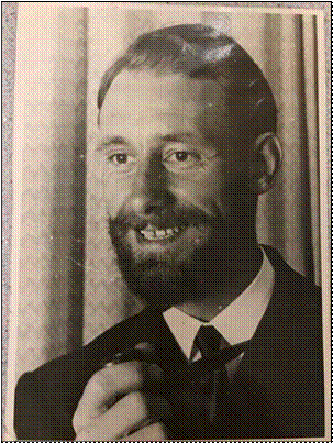
Robert William Sandilands
"Sandy" Sandilands was born and educated in Edinburgh, Scotland, and joined the Royal Navy in 1942. He trained as a pilot in the Fleet Air Arm but after writing off one aircraft, agreed with the Admiralty's assessment that the war would cost less if he changed careers. Sandy obtained his Commission and was appointed to Combined Operations aboard Landing Craft. After the war, he served with the fleet until 1948 when he became a hydrography (H) specialist. He had his first command in Home Waters and later was an assistant on surveys in the Mediterranean Sea, the Red Sea and the Persian (or Arabian) Gulf. In 1954, he resigned his commission and came to Canada alone four days after his marriage, and served with the Canadian Hydrographic Service until his retirement in 1989, by which time he had reached the position of Assistant Director, Hydrography, in Pacific Region. Sandy started his career with CHS with a few months at Headquarters before being assigned to the Pacific Region. After four years as Senior Assistant on the Marabell and on the William J. Stewart, he became Hydrographer-in-Charge of the Marabell in 1958 and in 1967 the William J. Stewart.. Later Sandy was HIC of the Parizeau in the western Arctic and when Central Region moved from Ottawa to Burlington, Sandy had a one year assignment to Central Region as Assistant Regional Hydrographer. In 1975, Sandy swallowed the anchor, and came ashore as head, Sailing Directions, Pacific Region, and remained there until he was appointed Regional Field Superintendent, the position he retired from on Oct. 30, 1989. He obtained his CLS Commission and served on the executive of the Association of Canada Lands Surveyors. He and his wife, June, are now enjoying retirement in Victoria, B.C.
Sandy has served on the Board of Trustees of the Maritime Museum of British Columbia, in Victoria. he has a keen interest in the history of hydrographic surveying and is the author of several papers on the subject. He served as associate editor (hydrography) of The Canadian Surveyor for several years, and as a councilor of the Canadian Institute of Surveying & Mapping.
Sandy co-authored with Stanley Fillmore the book for the CHS Centennial called "The Chartmakers".
Sources: The Canadian Surveyor, June 1982, p. 199.
The Canadian Surveyor, Autumn 1983, p. 197.
Lighthouse, Fall 1989, pp. 56-57.
Lighthouse, Fall 1995, p. 45.
1964 -Hydrographer in Charge - CHL OWL - Shore Party - off Victoria, BC
1966 - Field assignment, Pacific Region - Wm. J. Stewart (May 8 to May 28)
1966 - Staff assignment, Pacific Region - Education
1967 - Hydrographer in Charge - CSS Wm J Stewart - British Columbia - Coastal and Harbour (TO 7)
1969 - Hydrographer in Charge - CSS Wm J Stewart - Strait of Georgian and Prince Rupert area (ESS 8)
1973 (Annual Report) Hydrographer-in-Charge - CSS Pariseau - Natural Resource Char (TO 7)ting - Queen Charlotte Sound to beyond continental slope.
An article by Jan Drent in the Argonauta Winter 2020 issue on Sandy and his passing.
Robert William “Sandy” Sandilands 1925-1919
 West coast hydrographer “Sandy” Sandilands died weeks short of his 94th birthday in Victoria on October 6 2019 after a brief bout of cancer. Robert Sandilands had a 35-year career with the Canadian Hydrographic Service (1954-
89) after serving 12 years in the Royal Navy. His chart making career exemplifies that of so many British-born and British-trained seafarers who came to Canada in the decade after the Second World War to contribute their professional expertise to Canadian Government marine services, the RCN, and Canadian commercial shipping and pilotage.
“Sandy” Sandilands received his early education in his birthplace, Edinburgh. He joined the Royal Naval Volunteer Reserve in 1942, becoming an officer. After the war he transferred to the Royal Navy and joined the hydrographic service in 1948. By the early fifties he was commanding inshore survey vessels. He left the RN in 1954 to join the Pacific Region of the Canadian Hydrographic Service (CHS). Sandy served briefly with the CHS in Burlington in 1970-71 but otherwise his hydrographic career was on the west coast. After years as Hydrographer-in-Charge in several survey vessels on the coast and the western Arctic he became Head of Sailing Directions, Pacific Coast, and finally Regional Field Superintendent.
He was co-author of The Chartmakers: The History of Nautical Surveying in Canada (1983) and published several papers on the history of hydrographic surveys. He was also the co-editor of the periodical The Canadian Surveyor.
Sandy’s active interest in marine history was demonstrated by his years of support and leadership in the Maritime Museum of BC, where he served as President 1973-77.
It’s been 30 years since “Sandy” retired but a tribute by George Schlagintweit of the CHS, the start of whose career overlapped with the twilight of Sandy’s, sheds light on the time:
Remembering Sandy Sandilands
I stopped in my tracks when I heard the sad news of Sandy’s passing, and took stock of how much the Canadian Hydrographic Service has changed since that fateful day in the winter of 1985 when Sandy and the late Tony Mortimer interviewed me for a job with the CHS. Sandy retired as the Regional Field Superintendent for CHS Pacific Region, the same position he held when he hired me … and incidentally the same position I substantively hold within Central & Arctic Region, although the title has changed somewhat.
What stuck out about Sandy?
Sandy loved his pipe … I suspect he probably spent more time fussing with it than actually smoking it.
In the mid to late 80’s, Hydrographers-In-Charge (HIC) were still producing their Field Sheets manually, which means that they were responsible for meticulously inking each (manually reduced) tiny sounding onto a large plastic manuscript in the exact geographically referenced location where that sounding was measured. Additionally, with the benefit of various techniques, the HIC had to ink the precise location of the coastline and low-water line on the Field Sheet, as well as all the aids to navigation that were observed while at sea. As the Field Sheet became more and more dense with data that the HIC had inked with painstaking pride, it stands to reason that the HIC became increasingly protective of this document. A junior Hydrographer like myself would be cautioned early on that you don’t dare touch a Field Sheet with your bare hands due to the oil on your fingers, let alone breathe over it.
That’s where Sandy comes into the picture. Sandy would regularly do Field Survey Inspections, to get out of the office and check on the troops. (Now that I am doing the job, the former is likely the real reason.) In anticipation of Sandy’s arrival, the HIC would tidy up the Hydrographic Lab and brief staff accordingly to ensure they would be on their best behavior. Within minutes of Sandy’s arrival, he would be leaning over the Field Sheet, asking lots of questions about the data, its quality and so forth. And then the pipe would come out. Inevitably, arms would be waving as a result of detailed explanations, with tobacco ash becoming air-bound as a result. As the ash lightly settled on the Field Sheet below, we junior Hydrographers would be entertained watching the HIC do all he could to stop his own head from exploding. Diplomacy at all costs.
Sandy was a great man. He was always deeply concerned with the well- being of his staff and he served the CHS with upmost pride and professionalism. I truly feel honoured to have launched my career with the CHS under his charge.
Robert Sandilands enjoyed a long retirement at the idyllic seaside home he and his wife June created in Victoria. His daughter Cate writes:
The stories that wove Dad's and Mum's and my lives together did not rest on the names of ships or the details of the locations he charted, much as I understand the importance of this information to others. I could tell you about the year he got stuck in the ice at the end of an Arctic field season. I think it was on the Parizeau. I could tell you about the sights and smells we encountered when Mum and I picked him up from ship in Port Alberni; I could tell you about his lifelong dislike of chicken because of RN shipboard cuisine (probably amplified by his culinary experience of the CHS); and many people could tell you about his truly wicked cribbage skills, honed from many years at sea.
One of my favourite possessions is a chart that Dad oversaw of the local waters around Cadboro Bay the year I was born (where he was posted so he could be close to mum): it was printed in 1964, so his name is on it. I definitely remember the pipe rituals and accoutrements. Pipe cleaners were an obligatory annual stocking-stuffer. I also remember his utterly perfect handwriting from so many years of marking charts by hand, and also his resigned frustration that I could never read a map without rotating it in the direction we were going. In general, though, Dad kept his home and work lives pretty separate; although I have taken many lessons from him over the years, perhaps ironically the ones I remember most strongly concern earth, fire, and air rather than water.
Robert William “Sandy” Sandilands has slipped his cable after a long life well lived.
Richard Sanfaçon
Bilingue
Éducation :
-Diplôme universitaire en géographie de l’Université Laval en 1978
-Accréditation professionnelle à titre d’arpenteur fédéral (af), (CLS)
-Certains cours du diplôme conduisant au MBA à L’université Laval
Expérience considérable de travail en hydrographie, expérience de la gestion de programmes en fonction des objectifs des programmes ainsi que des besoins des clients et des exigences opérationnelles ; et de la gestion des ressources humaines et financières :
-1979-1980, Préposé aux dossiers techniques, SHC, Québec
-1980-1982, Cartographe marin, SHC, Québec: Travail de mise à jour, nouvelle-édition. Participation à un levé de reconnaissance aux Iles-de-la-Madeleine. Participation à un levé de révision en hélicoptère couvrant tout le Québec fluvial à l’ouest du Saguenay, y compris les lacs St-Jean et Memphrémagog, la rivière Richelieu et Outaouais. Début de production d’une nouvelle carte.
-1982 Membre du comité organisateur de la conférence hydrographique au Concorde à Québec et présentation d’un exposé sur le besoin de plus grande communication entre hydrographes et cartographes.
-1982-1985 Hydrographe (hydrographe polyvalent, possiblement le premier du SHC!), SHC, Québec: Participation à plusieurs levés fluviaux et côtiers tant en Gaspésie, dans le bas St-Laurent, aux Iles-de-la-Madeleine, dans la région de Batiscan au Lac St-Pierre de même que sur la Basse-Côte-Nord de La Romaine à Blanc-Sablon tant à bord de navires tel le Navimar ou le Louis M. Lauzier qu’à bord de vedettes de différents types. En 1985, premier opérateur du « Polarfix » en production de levé hydrographique au SHC, lors d’un levé à Blanc-Sablon.
-1985 Analyste des publications sur les marées, courants et niveaux d’eau: SHC, Ottawa.
-1986 Hydrographe responsable du traitement des données (appelé « Second IC » dans les autres régions du SHC) sur un levé d’envergure aux Iles-de-la-Madeleine, hydrographe en charge (HEC) intérimaire pour deux semaines. Entrevue et participation à une émission de radio avec les médias locaux. Même chose au salon nautique de Montréal.
-1987 Cartographe marin pour un an (production de petites cartes), responsable d’un levé de nivellement à Rivière Portneuf. Superviseur en cartographie pour de courtes périodes.
-1988 Affectation à la section de développement pour 2 mois. Hydrographe en charge d’un levé hydrographique côtier majeur aux Îles-de-la-Madeleine impliquant 5 vedettes et un navire, de même que 24 personnes donc 14 directement sous ma supervision et 10 membres d’équipage sur le Lauzier. Superviseur en cartographie pour 2 mois en fin d’année.
-1989 De janvier à mars, superviseur en cartographie et gestionnaire de production cartographique intérimaire pour 2 semaines. Entrevue accordée à Radio-Canada à Vancouver à titre de président de l’Association canadienne d’hydrographie, section Québec. Hydrographe en formation sur le système à balayage (multi-transducteurs) du FCG Smith en Nouvelle-Écosse et à l’Île-du-Prince-Édouard, de mai à juillet. Hydrographe en charge sur le FCG Smith de août à octobre en Haute et Moyenne-Côte-Nord. Vérification de minutes hydrographiques effectuées par des firmes privées à contrat.
-1990 Membre du groupe de 1 HEC de chaque région choisi pour évaluer le navire « SWATH », F.G. Creed, et le sytème multifaisceaux Simrad, à St-John’s. HEC d’un levé majeur côtier de hauts-fonds du système LIDAR (LARSEN) sur le Louis M. Lauzier entre Sept-Iles et Havre St-Pierre. En sept. et octobre, HEC d’un levé multifaisceaux EM-100 avec le NSC Louis M. Lauzier au nord de l’Île d’Anticosti. Participation de UNB pour l’amélioration des systèmes de traitement de données et de la compagnie TSS pour évaluer un meilleur senseur de mouvement.
-1991 Vérification de minutes hydrographiques et membre du comité organisateur de la conférence hydrographique à Rimouski. HEC d’un levé fluvial majeur du port de Montréal impliquant 4 vedettes , une dizaine de personnes et un échange de personnel avec la région Scotia-Fundy. Première mise en application des étapes pré-levés de validation de documents et les étapes sur le terrain.
-1992 HEC d’un levé de révision effectué un peu partout au Québec. Vérification de levés effectués à contrat par la compagnie GPR. Supervision des tâches d’inventaire et du projet de mise sur pied d’un modèle de priorités.
-1993 Validation pré-levé et HEC d’un levé majeur fluvial dans la région de Répentigny et des Îles de Contrecoeur, et impliquant une dizaine de personnes dont 2 cartographes d’Ottawa. Superviseur en cartographie au niveau de la mise-à-jour soit la production d’annexes graphiques et d’avis aux navigateurs.
-1994 Superviseur en cartographie, mise-à-jour, production d’annexes graphiques et avis aux navigateurs. En mai, formation pratique sur le système multifaisceaux EM-1000 du FG Creed à St-John (NB) et dans la Baie de Fundy. Rencontre avec les leaders de OMG (Dave Wells, Larry Mayer et John Hugues Clarke). Participation au levé de la route de câble avec le Creed, entre l’Île du Cap Breton et Terre-Neuve. HEC d’un levé multifaisceaux sur le Creed dans la partie avale de la rivière. HEC d’un projet majeur de cartographie du parc marin Stellwagen Bank en partenariat avec OMG de UNB, et la firme privée « Applanix » pour les levés géologiques des États-Unis (USGS), succès total et mise au point d’un senseur de mouvement de haute précision.
-1995 HEC pour la deuxième partie du levé multifaisceaux pour la cartographie du parc marin du banc Stellwagen au large de Boston. HEC d’un levé multifaisceaux aux Îles-de-la-Madeleine pour la cartographie de l’habitat du homard pour un client interne à Pêches et Océans soit la Division des Invertébrés et de la Biologie Expérimentale. Hec d’un levé à balayage multi-transducteurs (Shoveller) dans la région de Chicoutimi, en collaboration avec la région Scotia-Fundy. HEC, cours levé de recherche d’équipement perdu en mer avec le FG Creed au large de Corner Brook.
-1996 Membre du comité pour l’évaluation des systèmes multifaisceaux pour faibles profondeurs en préparation pour l’achat national. Les EM-3000 sont retenus par le comité. HEC pour le projet «Strataform» de cartographie des fonds marins (EM-1000, FG Creed) au large de Atlantic City (New-Jersey) pour ONR (Office of Naval Research), HEC pour la poursuite de projets de cartographie marine avec USGS au large de la Nouvelle-Angleterre (Parc marin Stellwagen Bank, Baie Massachusetts, etc.) Coordonnateur pour le SHC sur le dossier Inondation Saguenay. Réunion avec le secrétaire d’état au développement régional, Monsieur Martin Cauchon. HEC d’un levé de vérification suite au déluge et entrevue accordé au réseau TVA local. Nommer au poste de gestionnaire intérimaire de la division D’Acquisition de données hydrographiques à l’automne et prise en charge du dossier du groupe sondage/chenal de la GCC qui est transféré au SHC. Défi intéressant de gestion des ressources humaines.
-1997 Poursuite de mon affectation à titre de gestionnaire int. de la div. d’Acquisition de données hydrographiques qui regroupent une vingtaine de personnes réparties dans les sections Marées, Courants et Niveaux d’Eau (MCNE), levés hydrographiques (IML) et groupe sondage/chenal (Québec). Retour dans mon poste de Chargé de projets en mai pour m’occuper de la section des levés (IML) dans le cadre du projet pilote avec Travaux publics et services gouvernementaux. Depuis ce temps, gestion de la section des levés à l’IML ( projet EM-3000, levé pour clients externes au ministère (compagnie, autres ministères, université, etc.), et support à l’équipe de gestion du SHC lorsque requis.
- 2000 De juin à novembre, Directeur int. Du SHC- Région Laurentienne.
-2001 Retour dans le poste de gestionnaire int. de la div. d’Acquisition de données hydrographiques au SHC, Région Laurentienne.
1982 à 2002 Nombreuses participations à des conférences internationales reliées au domaine de l’hydrographie et présentation d’exposés (" papers ") dont les plus récents portent sur l'étalonnage des embarcations de sondage et les possibilités de la cartographie des fonds marins à l'aide des sondeurs multifaisceaux.
Gère les projets et programmes qui lui sont confiés en fonction des objectifs et des exigences opérationnelles et surtout avec un grand souci de répondre aux besoins du client. Depuis environ 1986, où il a commencé à gérer des équipes, il a acquis l’expérience de la gestion tant des ressources humaines que financières associées aux divers projets et programmes. A démontré des qualités certaines pour assurer le succès du travail en partenariat avec des universités, d’autres ministères, des compagnies locales et étrangères, de même qu’avec des représentants du gouvernement américain.
G.M. Sarault
• 1960 - classification in 1960: Asst. Technician 2
April 1963 (CHS org chart)- Chart Corrections (Assistant Technician 2)
W.R. Sarty
• 1970 - Hydrographic Casual - Kapuskasing - Nfld, Northumberland Str ( 8 Sept - 7 Oct)
M. Sastre
• 1966 - CSS Kapuskasing - Gulf of St Lawrence ( 29 July to 27 Oct)
Charles Savary
1886 - 1941
born 28 February 1886 in Quebec (1901 cencus)
• 1905-09 - Lower St. Lawrence River survey.
• 1907-09 - survey of Ile du Bic to Ile Verte (chart 1204)
• 1910-11 - survey at Fort Churchill.
• 1911-13 - survey of Rivière Betsiamites to Ile du Bic (chart 1210)
• 1912 - Officer in Charge of LA CANADIENNE, Lake Superior survey.
• 1913-16 - Officer in Charge of CARTIER, Lower St. Lawrence River survey.
• 1917-18 - Officer in Charge of Lower St. Lawrence River survey.
• 1919-23 - Officer in Charge of CARTIER, St. Lawrence River estuary survey.
• 1923 - Officer in Charge of CARTIER, Saguenay River survey
• 1923 - Officer in Charge of CARTIER, Gulf of St. Lawrence survey
• 1925 - resigned to accept a position with Lands + Forest Branch, Province of Quebec
.
The surveying profession of the province of Quebec lost one of its most gifted members in the death, by accident, on July 29, 1941, of Charles Savary, Quebec Land Surveyor, Registered Engineer of the Province of Ontario and member of the American Mathematical Society.
One of the most versatile members of the staff of the Department of Lands and Forests at Quebec, Mr. Savary in addition checked and adjusted the compasses of ships requiring this service at Quebec, an operation doubly complicated since the war. He also lectured on astronomy, spherical trigonometry, navigation and other mathematical subjects at Laval University, Quebec.
At the time of his death Mr. Savary was about to board a ship to adjust the compass. He slipped from the gang plank and struck his head on a wharf beam; death was instantaneous.
Like many men who are brilliant mathematicians but who have a passion for its applications, Mr. Savary’s mathematics were largely self taught. Following a classical education in Montreal he joined the Hydrographic Survey of the Federal Government where he rose to command the hydrographic ship Cartier, his main work being on the river and gulf of St. Lawrence.
In 1925 he joined the executive staff of the Survey Service, Department of Lands and Forests, and moved to Quebec City. His abilities quickly won him the high regard of surveyors, and his experience in the adjustment of compasses on SGS Cartier was early drawn on for similar work on the many ships calling at Quebec. This work was complicated since the war by the fitting of ships with anti-magnetic mine cables, and it is understood that the results of his research on the Gyroscopic Compass have been of real service to the British Admiralty.
Mr. Savary was 54 years of age and is survived by his wife, the former Rose Jobin, 4 daughters and 2 sons.
His death is a real loss to the community in which he lived and worked and to the surveying profession of Canada.
Source: The Canadian Surveyor, October 1941, p. 26.
Dr. Rock Santerre from Laval University has written a paper about Charles Savary and can be accessed at https://console.virtualpaper.com/vol-47/geomatique_vol-47_no3_hiver_2021pdf/#32 (see pages 32-35). The paper is in French and was submitted in 2021.
F.R. Scandrett
• 1912 - Lower St. Lawrence River survey.
Staff Cmdr. W.L. Scarnell
• 1860 - As a Master, survey of Bay of Fundy (chart BA 353)
• 1862-71 – as a Nav. Lt., surveyed C Bonavista to Bay Bulls, under Orlebar (chart BA296)
• 1866 – as a Staff Cdr., surveyed Carbonear to Brigus, under Kerr (chart BA297)
V. Schecter
• 1960 - classification in 1960: Engineer 1
• 1968/69-Training-Hydro I
Photos: Hydro I 1968/69
1969 - Hydrographer - CSS Maxwell - Atlantic Provinces - from 29 Sept)
1970 - Hydrographer - Shore Party # 3 - Pubnico - Yarmouth, NS (227 April - 30 Oct)
Schwerer (French Navy)
• surveyed Newfoundland in 19th Century
G. Scott
• 1965 - Student Assistant - CSS Cartier - Lake Erie ( 22 May - 10 Sept)
1966 - Student Assistant - Rainy Lake survey (4 May to 10 Sept) from Calgary
John Scott
• 1915-16 - Chief Engineer, ACADIA, Halifax Harbour & Approaches
Lieut. P.F. Scott, R.N.
• 1860 - survey of Bay of Fundy (chart BA 353)
T. Searle
1967 - Summer student - Lake of the Woods survey, Ont - 12 May to 24 Aug
• 1946 - Student Assistant in Tides and Currents
• 1947 - Assistant Technician in Tides and Currents
• 1977-Training-Carto 1 (Class Photo)
W.H. Sellings
• 1960 - classification in 1960: Map Compiler and Computer 4 • April 1963 (CHS org chart)- Chart Inspection (Technical Officer 3)
1970 - Hydrographer - Shore Party # 3 - Pubnico - Yarmouth, NS (13 April - 3 Sept)
• 1970 - Hydrographer - Kapuskasing - Nfld, Northumberland Str ( 8 Sept - 30 Oct)
K. Setchell
1971 - Casual Employee - CCGS Jon A Macdonald -Eastern Arctic (28 June to 10 Nov) Separated
V.T. Shaffer
• 1983 –Strait of Belle Isle survey (FS 4962)
Mr. Shanks
• 1927 - appointed as an Instrumentman
• 1927 - Vancouver & Quatsino Sound surveys.
• 1927 - resigned at end of field season.
Lieutenant C.B. Shaw, R.N. (Ret'd.)
• 1914 - Hudson Bay survey.
• 6 August 1914 (2 days after war began) - took passage to Halifax to return to the Royal Navy.
Squadron Leader Shearer
• 1935 - inspection of harbour in Queen Charlotte Islands.
D. Shearn
• 1946-47 - appointed to Precise Water Levels section.
Captain P.F. Shortland, R.N.
• 1852 – as a Cmdr., surveyed off Halifax (chart BA345)
• 1853 - (as a Commander) surveyed Sable Island with Capt. Bayfield
• 1855 - As a Cmdr., surveyed Brier Island to Gulliver Cove, N.S. (chart 4323)
• 1860 - OIC of survey of Bay of Fundy (chart BA 353)
• 1861 - surveyed Petitcodiac River & Cumberland Basin (chart 4366)
T.A. Shortt
• 1919-22 - Chief Engineer, ACADIA
J.G. ("Jerry") Shreenan
• 1950 – survey of Coral Harbour (FS 2100)
• 1954-56 - HIC - CHL BOULTON, North Channel, Georgian Bay
• 1960 - surveyed Little Bay Arm (Notre Dame Bay), Nfld. (chart 4523)
• 1960 - classification in 1960: Engineer 3
• April 1963 (CHS org chart)- Central Region, Field Officer (as Engineer 3)
1964 - Senior Assistant Hydrographer - CSS Baffin - Bay of Fundy survey
1965 - Senior Assistant - CSS Baffin (Shore Party) - south shore of Nova Scotia and New Brunswick
1966 - Senior Assistant - CSS Baffin - Tail of the Bank
1969 - Senior Assistant - CSS Baffin - Gulf of St Lawrence (28 May - 2 Oct)
1970 - Senior Assistant - CSS Kapuskasing - Nova Scotia, Newfoundland, Northumberland Str (22 May - 30 Oct)
• 1921 - transferred from Printing Bureau to CHS as senior copper plate engraver.
• 1921-39 - senior copper plate engraver.
1967 - Hydrographic assistant - Lake of the Woods survey, Ont - (May 17 to 12 Oct)
• 1967/68-Training-Hydro I
Photos: Hydro I 1967/68
1968 - Hydrographer - Georgian Bay survey (1 May to 18 Sept)
1968 - Hydrographer - Revisory Surveys - Lake Ontario -18 Sept to 4 Oct (transfered from Tobermory)
1969 - Hydrographer - Lake of the Woods Survey, Ont (May 20 to Oct 9)
1970 - Hydrographer - Great Lakes revisory surveys - 4 May to 10 Oct
J.H. Simard
• 1931-39 - Chief Engineer, CARTIER.
Commander C.H. Simpson, R.N.
• 1900-01 -Officer in Charge HMS EGERIA, Discovery Passage, Seymour Narrows (chart BA3162, 3333)
• 1901-02 - Officer in Charge HMS EGERIA, Johnstone & Broughton Straits (Chart BA 581)
• 1902-03 - surveys off NW part of Vancouver I (chart BA 582)
J.A. Simpson
• 1903 (maybe earlier) - secretary to Mr. Stewart
• 1905 - resigned
Ralph S. Simpson
• 1931 - transferred from National Resources Branch, Dept. of the Interior as an experienced draftsman.• 1937 - transferred to the Drafting Office of the Map Service.
• 1939 - listed as a Senior Map Draftsman
• January 1941 - granted leave to join RCN.
• 12 July 1946 – resigned from Department
J.E. Sims (Mrs.)
• 1961 - Chart Production, Clerk (Clerk 3)
B.J. Siple
1967 - Hydrographic assistant (Casual) - Shore Party # 2 - Ship Harb to Sheet Harb, NS (19 June to 5 Sept)
• 1967 - Hydrographic assistant (Casual) - Shore Party # 1 western NS - (11 Sept to 27 Oct)
J.P. Skemer
• 1960 - classification in 1960: Map Compiler and Computer 3
• April 1963 (CHS org chart)- Technical Assistance (Dom Hyd Stall), Chart Documents, (as Technician 1)
R. Sloan
• 1967 - Summer Student - CSS Baffin - Grand Bank of Nfld (22 May - 1 Sept) from university
P.E. Smart
• 1947 - listed as Notices to Mariners, Pacific Office
D.S. Smeathers
• 1967 - Summer Student - Shore Party # 2 - Ship Harb to Sheet Harb, NS (15 May to 14 June)
1968 - Summer Student - Shore party - Ship Harb. to Sheet Harb, eastern NS - 4 June to 30 Aug
1969 - Summer Student - CSS Maxwell - Atlantic Provinces - (1 May - 29 Aug) to EOIT
Arthur John Robert Smedley
August 1, 1923 – January 16, 2004
John Smedley joined the CHS in pacific Region in the summer of 1977. He worked with the tidal group until his retirement at the end of 1989. During that time John participated in numerous field surveys on the BC coast and in the Western Arctic. He was a wonderful person to travel and work with, and his workmanship was always of the highest quality. He was also never at a loss for energy or good ideas. This was a real tribute to John when you consider he joined the CHS at an age when many of us are already starting to think about retirement.
During Western Arctic surveys we often collected beach pebbles while waiting for the helicopter to pick us up. John used these stones in jewelry that he made during the winter and sold locally and in the Western Arctic. Had e-Bay been active in the 80’s, I’m sure the demand for John’s jewelry would have increased tenfold.
While deploying a tide gauge through the ice one spring I had a disagreement with my two “techies” (John and Willie Rapatz) over the need for a tea break. When I decided we should continue working he and Willie had a brief discussion and immediately staged a work stoppage. The point was made and the stove and kettle were unpacked from the komatik for the required tea break. After the break we successfully completed the installation and returned to Pond Inlet.
John’s contribution to our increased understanding of tides in Canadian waters was significant and fortunately, like much of what we do in the CHS, this contribution is ongoing through improved tidal predictions and an increased understanding of tidal propagation (Arctic, se level change and crustal movement.
Source: Fred Stephenson, Lighthouse, Ed. 54, Spring 2004
Born in Kasuali, India, 1st August, 1923 and died at Oak Bay Lodge, Victoria, 16th January, 2004. John entered the Royal Navy from HMS Worcester in 1939, and served at sea throughout the war, ultimately as gunnery officer. He joined the Royal Canadian Navy in Halifax in 1953 and served at sea and in various executive shore billets until his retirement in 1968. In that year he and his family joined the regular flow of navy families from the Maritimes to lotus land. His love of art and of farming drew him away from the sea but he returned to it to work at the Institute of Ocean Sciences until 1988. He married his beloved Nella in 1955, and one of his final conversations with her a few days before his death began “You are as lovely as always.: He was generous of spirit, understanding of his accomplishments, generously kind, with a sense of humour as blest in capacity as his barrel chest. He was a gentleman in the truest sense of the word. He will be deeply missed by Nella, and his daughters Susan, Patricia (“Piet”), Shiela (Adrian), and Rosemary, and by his two beloved grandsons, Derek and Adam.
It is with great sadness that I inform you of the death of John Smedley. His obituary is included below.
John joined the CHS in Pacific Region in the summer of 1977. He worked with the tidal group until his retirement at the end of 1989. During that time John participated in numerous field surveys on the BC coast and in the Western Arctic. He was a wonderful person to travel and work with, and his workmanship was always of the highest quality. He was also never at a loss for energy or good ideas. This is a real tribute to John when you consider he joined the CHS at an age when many of us are already starting to think about retirement!
During Western Arctic surveys we often collected beach pebbles while waiting for a helicopter to pick us up. John used these stones in jewellery that he made during the winter and sold locally and in the Western Arctic. Had eBay been active back in the 80's I'm sure the demand for John's jewellery would have increased tenfold.
While deploying a tide gauge through the ice one spring I had a disagreement with my two "techies" (John and Willie Rapatz) over the need for a tea break. When I decided we should continue working he and Willie had a brief discussion and immediately staged a work stoppage. The point was made and the stove and kettle were unpacked from the komatik for the required tea break. After the break we successfully completed the installation and returned to Pond Inlet.
John's contribution to our increased understanding of tides in Canadian waters was significant and fortunately, like much of what we do in the CHS, this contribution is ongoing through improved tidal predictions and an increased understanding of tidal propagation (Arctic), sea level change and crustal movement.
• 1960 - classification in 1960: Tech Off 4
• April 1963 (CHS org chart)- Central Region, Field Officer (Technical Officer 4)
1965 - Senior Assistant - CSS Cartier - Lake Erie
• 1966/67-Instructor-Training-Hydro I (Class Photo)
F.C.G. Smith
1890-1983
• born 15 October 1890 in Quebec (1901 cencus)
Frank Clifford Goulding Smith, the last of the giants of the Canadian Hydrographic Service died on 27th November, 1983.
F.C.G., as he was commonly known, but never to his face, was born in Montreal in October, 1890 and was educated there before going to Acadia University for his diploma in Engineering and where he met his wife. He worked for the Canadian Pacific Railways, Mackenzie Mann & Co., contractors for the Great Northern Railway, and O'Brien Mines, Cobalt, Ontario before joining the Canadian Hydrographic Service in September 1914 where he was assigned to Automatic Gauging (now Tidal) Section. In 1915, he was assigned to CGS Acadia for surveys of the Gaspé coast.
In November 1914 [sic, actually 1915], he joined the Canadian Railway Construction Corps and went to France. In November 1917, he was commissioned as a Lieutenant with the Royal Naval Volunteer Reserve and was posted to HMS Hearty, part of the Naval Surveying Service, and spent the rest of the war carrying out surveys for mine-laying until demobilized in 1919. These two years gave him an admiration for the methods of the British Admiralty which still influenced him thirty years later. From 1920 to 1927, he worked as an assistant hydrographer on the Cartier and Acadia primarily in the Gulf of St. Lawrence. In 1925, he spent a season on CGS Lillooet on the Pacific Coast.
In 1928, he was in charge of a small party that established control and a tide gauge in Churchill in preparation for the 1929 survey from CGS Acadia of the harbour and approaches, chosen as the terminus of the Hudson Bay Railway. In 1928, F.C.G. Smith surveyed the south shore of Great Slave Lake to enable the Hudson Bay Company to begin barge operations on the Mackenzie Waterway. In 1930, he returned to Hudson Bay as first Assistant on CGS Acadia, equipped for the first Canadian echo sounder surveys of the coastal approaches to Churchill.
From 1931 to 1935, he was the officer-in-charge of the Hudson Strait survey, during which the south coast from Cape Prince of Wales to Cape Weggs, the north coast from Lower Savage Islands to Shaftesburg Inlet, and the western approaches were surveyed. Taken north each year by the icebreaker N.B. McLean, Smith had to establish a camp, an astronomical position and triangulation. Soundings were carried out from the 27' half-decked launch Discovery and the 35' Henry Hudson, complete with a tiller bar in the stern. To complement the charts, F.C.G. wrote the first Canadian sailing direction to the Hudson Bay route. His last field season was 1937 when he used a 44' launch Boulton in a survey of the Saguenay River.
That fall, he was appointed Superintendent of Charts, which involved preparing the specifications for all charts and their final checking. In the early 1980s, there were still a few senior cartographers who could remember that in fact F.C.G. did a major part of the selection of soundings to be shown, much of it during his lunch time. During the war, it was his job to see that the numerous demands for charts were met if need be by printing Admiralty Charts using the "reserve proofs" held for such needs. In 1947, he supervised the production of the first two recreational charts of the Rideau Canal, based on a quick reconnaissance survey. He also began the task of rationalizing the chart scheme that had grown rather haphazardly since 1883.
The major challenge after the war was to start charting the Arctic to meet the needs that had arisen during the war and to make use of the new maps, based on tri-metrigon aerial photography. It must be remembered that as late as 1944, the only charts available were those produced by the Admiralty from the Franklin searches, a century earlier.
In September, 1952, on the retirement of R.J. Fraser, he was appointed Dominion Hydrographer. In May of that year, he was the first Canadian representative to attend an International Hydrographic Conference, for Canada had joined the IHO in 1951.
It was under F.C.G.'s direction that CHS began its major postwar expansion. Much of this was devoted to surveys required for mineral development in the north, particularly the iron ore deposits on the east coast of Ungava Bay, which have yet to be brought into production. He also coordinated with the US Navy during the period 1955-57, the surveys of the shipping routes and landing sites required for the construction of the DEW Line. In 1955, he was also able to start the surveys in Georgian Bay and the North Channel that were eventually used in the first Canadian recreational charts.
The major organizational change implemented by him was to amalgamate the Tides and Current Survey Division and the Precise Water Levels Division into Tides, Currents and Water levels. On the technical side, he introduced Two-Range Decca, the earliest electronic positioning system, which presaged as major a revolution in hydrography as the advent of the echo sounder in 1930. One of his last innovations was the use of the helicopter and the Tellurometer.
It is likely that he himself would see CSS Baffin as his major monument. Commissioned late in 1956, she was the first Canadian hydrographic ship designed for use in the Arctic, carrying six launches and a helicopter and Two-Range Decca.
F.C.G. Smith retired after 43 years service in June 1957 and moved to Annapolis, N.S., where he died in 1983.
Sources: Lighthouse, Nov. 1983, p. 59.
The Canadian Surveyor, Spring 1984, pp. 65-66.
• born 15 October 1890 at Montreal, the son of F. Clifford Smith
• September 1914 - appointed to Automated Gauges section
• May/June 1915 - transferred to Lower St. Lawrence River survey.
• Fall 1915 - enlisted with Canadian Railway Construction Corps.
• 1917 - commissioned as Lieutenant, R.N.R. with the British Admiralty doing hydrography
• 1919 - returned from military service.
• 1919-20 -St. Lawrence River estuary survey.
• 1921 - Sept Iles & Lake Melville surveys
• 1921 - Sept Iles survey
• 1923 - Magdalen Islands survey.
• 1924 - Gulf of St. Lawrence & Mingan Islands survey
• 1925 - British Columbia coast surveys.
• 1926 - Mingan Strait survey, detached party Outardes Bay
• 1927 - Gulf of St. Lawrence North Shore survey.
• 1928 - Officer in Charge of Churchill Harbour survey
• 1929 - Officer in Charge of Great Slave Lake survey
• 1929 - special survey in Brockville area.
• 1930 - Sable Island -Newfoundland surveys
• 1931 - Officer in Charge of detached party at Wakeham Bay
• 1931-32 - wrote sailing directions for Hudson Bay Route.
• 1932-35 - Officer in Charge of shore party, Hudson Strait
• 1936 - report on ice in Lake St. Louis, currents in Montreal Harbour
• Dec. 1936 - promoted to higher classification
• 1937 - Officer in Charge of BOULTON, St. Lawrence River survey
• 1937 - last field season.
• fall 1937 - assumed duties of Superintendent of Charts.
• 1941 - current survey in Montreal Harbour
• 1940-52 - Superintendent of Charts
• 1952 - became Dominion Hydrographer
• spring 1957 - retired.
Gary Smith
Gary Smith graduated in 1989 from the Fisheries and Marine Institute of Memorial University, St. John’s Nfld., with a diploma of Nautical Science Technology and holds a First Mate, Intermediate Voyage, marine certificate. He worked as a merchant ship’s officer on various commercial vessels engaged in domestic and foreign trade prior to joining CHS in 1991 as Sailing Directions Officer for Newfoundland and Labrador.
Source: 1998 Canadian Hydrographic Conference Proceedings, p. 11.
G.L. Smith
1969 - Summer Student - CSS Kapuskasing - NS and NFLD (2 June - 29 Aug)
Julian C. Smith
• 1936-38 - sounded Lake Memphremagog (chart 1361)
Commander Maurice H. Smith, R.N.
• 1898-99 - Officer in Charge HMS EGERIA, surveyed Strait of Georgia
T.B. Smith
I think Bert Smith was a recipient of the Centennial Medal in 1967.
Source: David Gray
• 1957 – Rankin Inlet (Comp book 156160)
• 1960-61 - Officer in Charge of Harbour Breton, Nfld survey (chart 4645)
• April 1963 (CHS org chart) - Bedford Institute, Field Officer (Technical Officer 5)
1964 (winter) - Hydrogrpher - CSS Baffin - (in charge) British Virgin Islands survey
1966 - HIC, Baffin - Tail of the Bank
1967 - HIC, Shore Party # 1 - western NS - Kejimkujik Lake, Trinity Ledge, Pubnico to Yarmouth
• 1968 - HIC, ACADIA, Isle Aux Morts and Hamilton Sound, Newfoundland.
1969 - CSS Baffin - Gulf of St Lawrence (13 June - 4 July)
1970 - HIC - Baffin - Arctic Survey (6 July - 16 Oct)
Vicki Smith
Vicki received a Deputy Minister's Merit Award in recognition of her outstanding achievements as a chart corrector for the past five years. She has been with CHS for 16 years.
Source: Lighthouse, Fall 1995, pp. 57&64.
William Smith
• 1877-84 – [first] Deputy Minister, Department of Marine and Fisheries
• Cape William Smith near Port Burwell, NWT. named after him.
• Smith Rock, Manitoulin, named after him (White, p. 70, corrected)
Woodrow Wilson Smith
• 1964 - (this must be the same "Smitty") - Wm J Stewart - BC
1965 - in June hydrographic assistant, in July electronic technician - Eastern Arctic survey
1966 - Electronic Technician - Entrance to Georgian Bay - shore party - 5 to 25 May and 2 to 14 Oct
1967 - electronic technician - Central Region
1968 - Electronic Technician - Central Region
from Death Notice:
July 3,1919 - April 23, 2006
Born on Port Hood Island, Cape Breton, Nova Scotia, Woodrow (always known as "Smitty") had a life long career with the Canadian Department of Transport and Environment Canada. Until his retirement in 1981 he was Foreman of Electronics, Marine Sciences Branch at the Canada Centre of Inland waters in Burlington, Ontario. He will be missed by his family and the many friends whose lives he enriched.
Frederick Ramon "Fred" Smithers
1923 - 2006
Fred Smithers joined the Canadian Hydrographic Service in 1940 as a cartographer, the first such position on the Pacific coast. He was hired by H.D. Parizeau who was Regional Hydrographer at the time. Training was on the job and Fred learned "the trade" under the supervision of Parizeau and later R.B. Young. Unlike today's compilers and cartographers, Fred went to sea with the survey party and was expected to generally assist in the survey in addition to his draughting duties. He reminisced about one typical day which encompassed assisting in the erection of a tide pole, doing some draughting, practicing lettering and ended up washing out the chart room! He retired in June 1978 as Regional Chart Superintendent, (Pacific Region).
Source: Lighthouse, Nov. 1978, p. 27.
• 1940 - appointed as Student Draftsman, Victoria Office.
• 1945-47 - Chart Distribution, Pacific office.
• 1945 - tidal survey, Seymour Narrows.
1973 - Regional Chart Superintendent, Pacific Region
June 1978 - Retired from the Hydrographic Service
Published in the Victoria Times-Colonist on Jan 4, 2007:
Born 2 Sept 1923 in Vancouver, BC.
Died 30 Dec 2006
Went to school in West Vancouver. During the war worked for Boeing Aircraft in Vancouver. Moved to Victoria in 1945. He worked for the Canadian Hydrographic Service for 38 years before retiring as regional chart superintendent.
Commander Morris H. Smyth, R.N.
• "Maurice" in Thompson, Men & Meridians, Vol. 2
• 1898-1900 - Officer in Charge HMS EGERIA
• 1898 - surveyed Baynes Sound.
• 1898 – surveyed for a Pacific cable
• 1899 - Nanaimo Harbour survey (chart BA 573)
Lieut. S.K. Smyth
• 1906 – surveyed Port Simpson, under Learmonth (chart BA3678)
Capt. Donald Morrison Snelgrove, O.B.E.
1896- 1965
Born in St. John's, Newfoundland, February 1896, Captain Donald Morrison Snelgrove had his first introduction to hydrographic surveying in 1912 when he shipped as a cabin-boy on the Admiralty vessel Ellinor, Capt. J.W.F. Combe, R.N., in command. This survey incidentally was the last Admiralty charting in Canadian Waters prior to World War 1.
Between the years 1918-19, he was with the Department of the Naval Service, and the Fisheries Protection Service in the Department of Marine and Fisheries. His first appointment with the Hydrographic Survey was in 1922 when he became Second Officer of the survey vessel Acadia. From 1924-27, he was with the Canadian Government Merchant Marine, and in may 1927 returned to the Hydrographic Survey as First Officer of the Acadia. In 1929, he was promoted to the rank of Sailing Master, C.G.S. Bayfield. Surveys that year were completed in the Gulf of St. Lawrence, and the following year the Bayfield was sent to Lake Superior where she charted 'Superior Shoal' lying near the main steamship tracks in the centre of the Lake. In the summer seasons of 1932-35 'Cap' Snelgrove was attached to shore-party surveys in Hudson Strait. In June 1940, he enlisted in the Royal Canadian Navy, and was discharged in 1945 with the rank of Lieutenant Commander.
Upon his return to the Hydrographic Service, Captain Snelgrove was appointed Master of the Acadia in 1946, and the Kapuskasing in 1949. In 1956 he was detached from sea duty to supervise the construction in Montreal of the new survey vessel Baffin. When constructed, he was appointed its first Master. In 1958, he was assigned to the duties of shore-captain working between the equipment depots located in Halifax and Pictou, N.S. With the founding of the Regional Office of the Hydrographic Service in Halifax 1959, and the Bedford Institute of Oceanography in Dartmouth 1962, Captain Snelgrove was attached to these depots. He retired from the Hydrographic Service in January 1963.
Always of a cheerful disposition he was well-liked by his fellow workers, and had the honour, never acquired by any other ship officer of the Hydrographic fleet, of having served under all six of Canada's Chief and Dominion Hydrographers. He died following a long illness at Camp Hill Hospital in Halifax November 9th, 1965, aged 68 years.
Source: Soundings, August 1966.
• served as 'cabin-boy' to Capt. J.W.F. Combe, Newfoundland Survey
• 1912 - stayed with ELLINOR on survey to West Indies (Kingston & Port Royal)
• paid off in London & returned to Canada
• 1928 - First Officer, ACADIA
• 1929-31 - Sailing Master BAYFIELD (II)
• 1932-35 - looking after the boats, shore party Hudson Strait.
• 1939 - HENRY HUDSON, Quebec City
• 1940 - Northumberland Strait survey
• summer 1940 - joined RCN
• saw war-time military service
• 1946-48 - Sailing Master, ACADIA
• 1949-55 - Captain of KAPUSKASING
• 1950 - Labrador Coast
• 1957 - Captain of BAFFIN
1961 - Atlantic Region, Technical Officer (Technical Officer 8)
• 1963 - retired.
Don W. Snodgrass
• April 1963 (CHS org chart)– Central Region, Field Officer (Engineer 1)
1964 - Hydrographer, CSL Rae - Great Slave Lake and Mackenzie River, NWT
1965 - Hydrographer - Trent-Severn Waterway survey, Ontario
1966 - Hydrographer-in-Charge, Shore Party - Trent-Severn Waterway, ON
Ronald Solvason
RONALD SOLVASON - EMPLOYEE WORK HISTORY
BIRTH DATE:25-Nov-49
MARITAL Status: Married
EDUCATION: Algonquin College - Civil Technology - 3 years
Hydrography I - 1973
In House Courses: Fortran IV, INDAPS
Report Writing Course
Hydrography II - 1976
CLS Commission - 1993
JOINED: 07-Jun-72
May 5, 1969 - Seaman (summer employment)
1970 - Student Assistant (summer employment)
June 7, 1972 - TIRL
July 1, 1973 - ESS-3
July 1, 1974 - ESS-4
Nov. 1, 1975 - ESS -5
May 1978 - ESS-6
Feb. 1, 1983 - ESS-7
Jan. 2, 1998 - A/ENSUR 04
Oct. 10, 2005 - A/ENSUR 05
RONALD SOLVASON - EMPLOYEE WORK HISTORY
YEAR ASSIGNMENT HIC, SUPERVISOR/MANAGER
1969 Lower St. Lawrence Survey J.I. Robichaud
1970 Lake-of-the Woods Survey C. Leadman
1972 James Bay Shore Party Survey Bruce Wright/Jake Kean
1973 Hydrography I
Hydographic Training cruise - British West Indies
Hamilton Harbour Survey Ab Rogers
Lake Winnipeg Survey R. Lewis
1974 Spring Control Survey Jake Kean
Thames River F.L. DeGrasse
Thunder Bay Survey J.V. Crowley
1975 Lake Huron Survey Ab Rogers/Paul Davies
1975/1976 Ships Division CHS Rotational Assignment
1977 Lake Huron Offshore survey (Bayfield) Jack Wilson
1977 Acting Tidal Technician B. Tait
1978-1980 Tidal Technician B. Tait
1981 Tidal Technician A/EG -7 Mar. 1 - May 15 Dennis St. Jacques
in charge of Arctic Tidal Survey program
1982-1986 Tidal Technician Dennis St. Jacques
1987-1996 Tidal Technician Rick Sandilands
1998-1999 Tidal Technician A/Head TCWL Rick Sandilands
2001-2003 A/Head Hydrodynamic Data Acquisition Rick Sandilands
2004-2005 A/Head Hydrodynamic Data Acquisition Jon Biggar
2005 A/Manager Technical Services K. Weaver
R. Solvason - from final field reports:
1970 - Student Assistant - Lake of the Woods survey ( May 18 - Sept 2)
• born 31 July 1868 in Quebec (1901 cencus)
• 1905-06 - St. Lawrence River survey.
• 1906-07 - compiling St. Lawrence River charts.
Miss Soulsby
• 1947 - listed as Student Draftsman, Pacific Office.
Lt.Cdr. H. Soulsby, R.C.N.
• 1935 - in command of HMCS ARMENTIERES, inspection of several harbours in Queen Charlotte Islands
Mrs. M. L. Soutar
• see Miss M.L. Cumbers
• 1961 - Tides and Water Levels, Assist. Technician (Assist Technician 3)
• April 1963 (CHS org chart)- Tides and Water Levels, Technical Information (Assistant Technician)
Captain R.M. Southern
Richard Meuric Southern (always known to his contemporaries as Sam) began surveying as a lieutenant when he joined HMS Mutine for a commission in the West Indies and Bermuda in 1920. He was next, from 1922 to 1924, in HMS Kellett working on the east and south coast of England. In 1925, he went to HMS Endeavour working on the west coast of Africa, in the Mediterranean and the Red Sea. During this time, the ship grounded on a reef off Jeddah, but got off without material damage. From 1927 to 1929, he served in HMS Iroquois in the South China Sea and the Malacca Strait. This was followed by two seasons in HMS Beaufort on the west coast of Scotland and the north coast of Wales.
In 1930, Southern came into the Hydrographic Department as naval assistant to the Hydrographer. In the next year, he took command of HMS Kellett in the Thames Estuary and on the east coast of England. In 1933, he went to HMS Endeavour, surveying on the west coast of Africa, in Palestine, in the Maldives and on the west coasts of Siam and Malaya. He was appointed commander in 1934. During the Abyssinian crisis of 1935, the ship was held at Aden, with Southern temporarily becoming Naval Officer in Command. This was repeated during civil disturbances the following year.
In 1937, he was in the Hydrographic Department writing the new Admiralty Manual of Hydrographic Surveying, and in 1938 commissioned the new HMS Gleaner for work in the English Channel, Isle of Man and the west coast of Scotland. In 1939, he went out to HMS Herald on the east coast of Malaya until she was paid off on the outbreak of the Second World War.
During the war, Southern was the first Fleet Hydrographic Officer Mediterranean, surveying with auxiliary craft in the Red Sea and the coasts of Egypt and Crete, being promoted captain in January 1942. He came into the Hydrographic Department as Assistant Hydrographer in 1942, then returned to the Mediterranean as Fleet Hydrographic Officer from July 1943 for six months, before becoming Superintendent of Charts at the end of 1943. He went back to the Mediterranean once more as Fleet Hydrographic Officer for a few months at the end of 1944 before returning to the post of Assistant Hydrographer again in 1945. Southern went back to sea in 1946 in command of HMS Challenger for surveys in the Persian Gulf, in Cyprus and at Gibraltar. He came ashore finally in 1949 to take up the post of Assistant Hydrographer for the third time.
He retired in August 1950, and from 1951 to 1958 was adviser successively to the Nigerian, Turkish and Canadian governments, besides spending a short time revising supplements to Sailing Directions.
Source: © Morris, R.O., Charts and Surveys in Peace and War, pp. 69-70.
Captain R.M. Southern, R.N., was contracted during 1957-58 to write the three volumes of the Arctic Pilot. The books were welcomed by mariners and outsiders as they provided the sole source for climate, ice conditions and village information.
Source: Gray, D.H., Men & Meridians, Vol. 4, unpublished.
George A. Spear
• 1961 - Headquarters Staff, Admin Officer (Admin Officer 9)
1968 - Hydrographic Assistant - CSS Acadia - Nfld (8 July to 14 Oct)
• 1968/69-Training-Hydro I
Photos: Hydro I 1968/69
1969 - Hydrographer - CSS Kapuskasing - Revisory survey NS, Fogo Isl NFLD
1970 - Hydrographer - CSS Kapuskasing - Nova Scotia, Nfld, Northumberland Str. (19 May - 3 Sept)
resigned 3 Sept 1970
G.R.(or R.G.) Spencer
• 1960 - classification in 1960: Draftsman 3
• April 1963 (CHS org chart)- Drafting and Reproduction, Unit 2, Group C (Draftsman Grade 3)
J.G. Spencer
• 1947 - Queen Charlotte & Smith Sounds surveys
• 1947 or early 1948 - resigned
J. Spencer
1967 - Student Assistant - Lake Surveillance Program
S. Spencer
• 1966 - Technician - CSS Baffin - Tail of the Bank (6 Aug to 10 Nov)
1970 - Hydrographic Assist -
A. Stachiw
• 1964 - 25 June - 19 July, attached to CSS Kapuskasing - Chaleur Bay (from Ottawa)
Arnie R. Stanzel
• 1960 - classification in 1960: Map Compiler and Computer 4
• 1962 - in Chart Compilation
• April 1963 (CHS org chart)- Chart Compilation (Map Compiler and Computer 4)
• 1966 September, Joined Canadian Hydrographic Service
• Oct. '66 - Mar. '67 Basic Training, Ottawa and the Caribbean
• 1966/67-Training-Hydro I-(CHS Class Photo)
• Apr. '67 - Mar. '68 Georgian Bay Surveys
• Apr. '68 - Mar. '69 Trent Severn Surveys
• Apr. '68 - May '69 Step 2 Training
• Jun. '69 - Mar. '70 Lake of the Woods Surveys (Senior Assistant)
• Apr. '70 - Apr. '71 Transferred to CCIW – Inland Waters
• April, 1971 Rejoined CHS
• Apr. '71 - May '72 Georgian Bay Surveys
• Jun. '72 - Sep. '72 On loan to Pacific Region – Western Arctic
• September, 1972 Commenced University training
• Summer, 1973 HIC Navigational Range Surveys
• " 1974 HIC Revisory Surveys
• " 1975 HIC Revisory Surveys
• May, 1976 Departed CHS, joined Marshall Macklin Monaghan
• Graduated – Survey Science, University of Toronto
• February, 1979 Commissioned Ontario Land Surveyor
• June, 1980 Commissioned Canada Lands Surveyor
• 1991 - 1992 President, Association of Ontario Land Surveyors
• 1999 - 2000 President, Association of Canada Lands Surveyors
• 1987 - Present Senior Vice President in charge of Geomatics Division,
Marshall, Macklin, Monaghan
Major Stearns
• 1910 - on icebreaker STANLEY, en route to RNWMP station at Fort Churchill.
Fred Stephenson
Fred Stephenson graduated from the University of Victoria with a B.Sc. in Physics (1972). He joined CHS in 1972 and has been involved in the study of tides and currents since that time. From 1990 to 1994 he was Regional Tidal Superintendent (Pacific). He is presently Manager, Geomatics Engineering (Pacific) and chairs the CHS Tides, Currents and Water Levels Committee. In that capacity he is responsible for coordinating tides and currents expertise within CHS, and for overseeing production of the Canadian Tide and Current Tables predictions.
Source: 1998 Canadian Hydrographic Conference Proceedings, p. 11.
A.E. Stewardson
• graduate of University of British Columbia
• March 1929 - appointed to CHS
• 1930-36 - west coast Vancouver Island survey.
• 1937 - Rivers Inlet survey.
• 1939-40 - Strait of Georgia survey.
• 1940 - suffered a nervous breakdown during the field season
• July 1941 - retired due to ill health.
Ian Stewart
• assistant with St. Lawrence Commission
• 1915 - St. Mary's River stream flow survey.
William James Stewart
1863-1925
born 23 November 1863 in Ontario (1901 cencus)
William J. Stewart was born in Ottawa on January 23, 1863, the son of Major John Stewart, a contractor in Ottawa and also Commanding Officer of the Ottawa Field Battery. William Stewart had received his education at Collegiate School (now Lisgar Collegiate) in Ottawa. On February 5, 1880, at the age of 17, he joined Royal Military College (RMC), having taken first place in entrance marks in his class of seventeen. As Company Sergeant-Major in the Cadet Battalion, he graduated on June 26, 1883, at the top of his class at RMC. He was presented with the Governor General's Gold Medal, awarded to the cadet standing first in General Proficiency, as determined from the date of joining to that of graduation. RMC records show that he was 5'7" tall, with dark complexion, brown hair and hazel eyes.
Stewart started work for the Rideau Canal Office, Ottawa, and joined the one-year old Georgian Bay Survey (later to become the Canadian Hydrographic Service) on March 22nd, 1884 at an annual salary of $550. He took over as Chief Hydrographer in 1893 and continued to survey in Georgian Bay and the North Channel until 1894. (1891 was his only absence - as then he was sent to survey Burrard Inlet in British Columbia.) In 1895-97, Stewart with his ship Bayfield was in Lake St. Clair, Lake Erie and Lake Huron. In 1898, he was back at Parry Sound. During 1901, Stewart took part in the first year of the Lake Winnipeg survey, but for the next two years, he was in Lake Superior surveying with a new Bayfield.
Stewart probably recognized the validity of the argument that the masters of a ship placed greater faith in a chart surveyed by a fellow navigator by obtaining his Master's Certificate, Inland Waters in 1897, though he never commanded his own survey ship.
W.J. Stewart also carried out several important works on behalf of the Dominion and British governments. He was a member of the International Waterways Commission in 1909. Later, when the Chicago drainage scheme was a matter of international importance in 1912-13, he was appointed by the Dominion Government to determine its effect on the level of the lower St. Lawrence River. At the request of the British Government, he went to Europe to assist in layout the new international boundaries as determined by the 1919 Treaty of Versailles.
Stewart died on May 5, 1925, leaving his wife, Clara Lasher, and two unmarried daughters, Avis and Sybil. He is buried in Beechwood Cemetery, Ottawa.
Sources: Obituary of William J. Stewart, Ottawa Citizen, May 1925.
Sandilands, The Canadian Surveyor, June 1982. p. 156 & 159.
Canada's First Chief Hydrographic Surveyor - Mr. Wm. J. Stewart, 1863-1925
WILLIAM JAMES STEWART was born in Ottawa January 3rd, 1863, and graduated as a Gold Medallist form the Ottawa Collegiate Institute in 1879. He was also a First Graduate, and Gold Medallist, from the Royal Military College in Kingston, in 1883. In July of that year he was employed by the Department of Railways and Canals as a compass engineer, and worked on surveys in connection with the Gananoque and Devil's Lake water investigations. He transferred to the Marine and Fisheries, and on March 22nd, 1884 was named assistant surveyor to Staff Commander J.G. Boulton, R.N., Officer-in-Charge Georgian Bay Survey, in the Great Lakes, with a salary of $550 per annum. At that time he was a Lieutenant in the Canadian Militia. Under Staff Commander Boulton's tutelage Mr. Stewart's progress was most rapid, and in the following year (1885) he was placed in charge of the first hydrographic shore-party. After five years of hydrographic surveying the Government was most anxious for him to take over this work, but he was not ready. In a letter he wrote two decades later to a senior officer he reiterated those remarks, and added, "but the latter (meaning Commander Boulton) did not consider that I was qualified, and I know perfectly well now that he was right".
In May 1889, he became the first permanent employee in the Hydrographic Service, and two years later made the first survey on the seacoast (Burrard Inlet, B.C.). Following a re-organization in the Department of Marine and Fisheries in 1892, Staff Commander Boulton returned to England. Early in April 1893 Mr. Stewart succeeded him as Officer-in-Charge of the Georgian Bay Survey. To better qualify himself for the work under his charge, in April 1897 he successfully passed his Master's examinations at Kingston, Ontario, and was granted Certificate No. 2123, effective April 27, 1897. Mr. Stewart thus became the first Canadian hydrographer to hold Master's Papers (Inland Waters). For some unknown reason, however, he never called himself "Captain", like his successor Capt. F. Anderson.
From 1893 to 1900 he completed the recharting of the Canadian shores of Lake Huron, including Georgian Bay and the North Channel, and Lake Erie. In 1901 he undertook the first hydrographic survey in Lake Winnipeg, and in the following year returned to the Great Lakes to commence the resurvey of Lake Superior. He was named Chief Hydrographer in August 1904, and that year ended his survey days on the Great Lakes. His last field season was 1905 when he began the first 'salt-water' survey on the East Coast (Lower St. Lawrence River). From then until his untimely death in the Ottawa Civic Hospital May 5th, 1925 he made Ottawa his headquarters where he was fully occupied with national and international hydrographic problems, and in planning the Hydrographic Survey of the future.
Mr. Stewart had the reputation of being a good mathematician and work closely with Dr. W.F. King and Dr. O.F. Klotz of the Dominion Observatory on survey problems pertaining to the seacoast. In April 1907 he wrote, "on account of my experience on, and knowledge of the St. Lawrence waterway I was selected by the Government to succeed Dr. King, as Commissioner on the International Waterways Commission" (renamed International Joint Commission, January 1909). Together with the American Commissioner Dr. E.E. Haskell, Dean of Civil Engineering, Cornell University, Mr. Stewart was appointed to a special committee and given part responsibility for formulating plans for, and the delineation of, the International Boundary between Great Britain and the United States, according to Article IV of the Boundary Treaty, signed at Washington, D.C. April 11th, 1908. The care and maintenance of the boundary monuments erected on the Great Lakes and River St. Lawrence, in accordance with the Treaty's definition and delineation agreed upon, were then placed under the Hydrographic Survey until the International Boundary Commission was formed in 1925.
Mr. Stewart also held the following important positions in connection with water-level regulations: Canadian Representative on the International Boards of Control for Lake Superior, and St. Croix River, N.B.; Chairman Board of Control Lake of the Woods; Member Dominion Water Power Board. In October 1912 he was named Consultant Engineer to the Prime Minister and the Department of External Affairs on common problems relating to International Joint Commission matters between Canada and the United States.
Following the First World War, in 1919 he was named as advisor to British Government in the demarcation of the boundaries in Europe, as agreed by the Treaty of Versailles. When as International Committee was set up in Paris in 1920 to consider draft conventions on world communications and transportation, he was appointed a British Empire Representative. At the first Conference on Communications in 1921, Canada was represented by the High Commissioner in London, Sir George Perley, and Mr. Wm.J. Stewart, as Consultant Engineer to the Department of External Affairs. These international problems were to occupy most of Mr. Stewart's time for the remainder of his career.
Back in 1910, Mr. Stewart suffered a severe illness that crippled his right arm, from which he never fully recovered. Throughout his entire career he had a reputation of being tough, exacting, and most demanding. He would frequently criticize his own Service but he would not tolerate any outside interference. Typical of Mr. Stewart are two of his own statements. One was in connection with charts, and was directed to a senior hydrographer in January 1919, "I am responsible for the issue of charts by the Dominion of Canada, and you are responsible for sending accurate charts to this office." Another was in connection with money matters, and sent to the same hydrographer May 1913, "I feel that all the vote for hydrographic surveys is under my control, and I do not allow anyone, not even the Deputy, to give orders for the expenditure of any part of it without a protest." From general hearsay, pecuniary restraints were characteristic of Mr. Stewart during his term of office, and are reported having had an adverse effect on the progress of the Survey and the general welfare of its staff. However, there were few who worked under, and with him, who did not admire his high sense of honour and judicial nature, and held him in high esteem.
At the time of his death, aged 62 years, Mr. Stewart was an Executive Member of the Section of Oceanography, National Committee of Canada; International Union of Geodesy and Geophysics; Member of the Engineering Institute of Canada; American Society of Civil Engineers; Institute of Civil Engineers, London, England; the Geographic Board of Canada; the Royal Astronomical Society of Canada. He was survived by a widow and two daughters.
To Canada's First Chief Hydrographer, Mr. R.J. Fraser wrote this tribute in later years, "about 170 navigation charts of Canada are either the product of his own skilled hand or result from the responsible planning and production during the years of his personal administration of the Service." A noble and parting tribute to a man who devoted forty-one years of his life in recharting Canada's inland and coastal waters, and to the heritage he left his successors.
Source: Meehan, O.M., The History of the CHS from its Inception to the Second World War, Unpublished manuscript, chapter 2.
• 1901- surveyed St. Clair River to Goderich (chart BA3390)
• 1905 - Officer in Charge of GULNARE, NS surveys
• 1906 - first full year in Ottawa; i.e., no longer field duties.
• 6 April, 1907 - appointed Commissioner International Waterways Commission.
•Stewart Island, Algoma and Stewart Rock, Owen Channel, Manitoulin named after him.
R. Stewart
• 1940 - listed as Office Boy at Headquarters.
Charles H. Stirling
• 1983 –Strait of Belle Isle survey (FS 4962)
R. Stock
• 1964 - Electronic Technician - 1 June - 5 July, CSS Kapuskasing - Chaleur Bay (from BIO)
1964 - Electronic Technician - 10 Aug - 15 Oct, CSS Acadia - Nfld
Reginald 'Reg" H. Stone
From local Memory:
Reg served as Ship's Writer on many hydrographic cruises.
1960 - Ship's Writer - Acadia
1961 - Ship's Writer - Baffin
• 1961 - Atlantic (or Central) Region, Clerk (Clerk 3)
From Obituary:
STONE, Reginald H. "Reg" - 82, Windsor, passed away on Friday, December 30, 2005, in Hants Community Hospital, Windsor. Born on September 28, 1923, in Oxford Junction, Cumberland Co., he was the son of the late Percy and Gertrude (Brenton) Stone. Reg was the former director of the Nova Scotia Freemasons Home, Windsor. He had worked in the Ships Division of the Bedford Institute of Oceanography and also worked at the Co-op in both Stewiacke and Brooklyn. He is survived by a son, Danny Castillo, Dartmouth; sisters, Helen Archibald, Truro; Erma (Gordon) Card, Aylesford; Hazel Hathaway, Westville; brother, Hector (Jessica), New Glasgow; several nieces and nephews.
G.S. [or G.P. or G.W.] Stoney
• 1939 - clerk-stenographer, Victoria office.
• 1940 - grant leave to join RCAF
• 1945-47 - clerical & administration, Pacific office.
Bob Strachan
BOB STRACHAN - EMPLOYEE WORK HISTORY
WORK YEAR WORK ASSIGNMENT HIC, MANAGER/SUPERVISOR
17-Jun-74 (joined CHS???)
1998 Revisory Survey Raj Beri
Jan '01 - Mar '01 Data Management Don Robertson
2002 Data Management Don Robertson
2003 Sailing Directions Sam Weller
2004 NIO Sandy Bishop
F. Strachan
• 1960 - classification in 1960: Superv Draftsman 3 • April 1963 (CHS org chart)- Chart Drafting and Reproduction, Head Unit 2 (Technical Officer 5)
N.(Nick) H.J. Stuifbergen
• 1960 - classification in 1960: Tech Off 1
• April 1963 (CHS org chart)– Central Region, Field Officer ( as Technical Officer 1)
1964 - Polar Continental Shelf Project - Hydrographer - Fram Sd & Hell Gate
1966 - Field assignment, Central Region - Polar Continental Shelf Project
1967 - Hydrographer - Georgian Bay survey - 15 May to 14 Sept
1968 - Hydrographer - St. Lawrenc River Survey, Ont and Que - 6 May to 14 Sept (then to Carleton U)
1969 - Hydrographer - Lower St Lawrence Survey (Minifix) 3 May to 27 Sept
Nick Stuifbergen will be retiring May 31, 2007 with 46 years of service. Nick started in Central Region in 1961, where he took part in many surveys including the Polar Continental Shelf Project. Nick moved to Atlantic Region in 1972. He is well known for his work in Loran-C latticing and datum shifts. In recent years, Nick has been responsible for developing algorithms and enhancing techniques in support of referencing products and source information that has no horizontal datum reference, or transforming the data from an obsolete and seldom used known datum.
Immediately following his retirement, Nick will continue his research with CHS as an appointed Science Alumnus member at Bedford Institute.
Retirement News from CHS Atlantic (2007)
Germain Augustin Surette, D.L.S.
• born 30 July 1890 in Nova Scotia (1901 cencus)
• Dominion Land Surveyor. #718 (1927), of Ottawa
• previously employed by Topographical Survey of Canada, Dept. of the Interior.
• 1937-38 - Cape Breton Island survey
• 1938 - Northumberland Strait survey (did 150 miles of plane tabling of coastline)
• 1939 - east coast of Cape Breton survey.
• 1940 - Northumberland Strait & Shelburne Harbour
• 1941 - St. Lawrence River & Newfoundland surveys
• 1942 - Gulf of St. Lawrence survey
• 1943 - Bay of Fundy survey
• 1944-46 - Northumberland Strait survey
• 1947 - Northumberland Strait survey
• 1947 - surveyed Merigomash Harbour, N.S. (chart 4445)
H.B. Sutherland
• April 1963 (CHS org chart)- Bedford Institute, Electronic Technician (as Technician 4)
1964 - Electronic Technician - CSS Baffin - 17 - 21 Aug - Bay of Fundy survey
J. Sutherland
• 1970 - Summer student - Saint John River survey NB ( 21 May - 28 Aug) from NSLS
Miss L.W. Sweet
• Dec. 1941 - appointed Student Draftsman as chart corrector.
• 1942 - resigned
R.F. Swain
• 1961 - Headquarters Staff, Technical Officer (Technical Officer 10)
H. Swan
• 1903 - seasonal staff, Lake Superior survey.
T. Swan
1967 - Student Assistant - Lake Surveillance Program
J.G. Swayze
1962 - Joined CHS
• April 1963 (CHS org chart)- Notices to Mariners (as Map Compiler and Computer 1)
1967 - working level compiler - transfered to Nomenclature
S.G. Swettenham
• 1960 - classification in 1960: Draftsman 3
• April 1963 (CHS org chart)- Drafting and Reproduction, Unit 1, Group B (Draftsman Grade 3)
M.G. Swim
• 1960 - classification in 1960: Tech Off 3
• April 1963 (CHS org chart) - Central Region, Field Officer (as Technical Officer 3)
1964 - Hydrographer - assisted in Halifax harbour survey
1965 - Hydrographer - CSS Maxwell, CHL Eider - Nova Scotia, New Brunswick and Gulf of St. Lawrence
1966 (Field Program) In charge of installing, inspecting and maintaining tide gauges - East Coast and Arctic
1967 - Officer in Charge - Eastern Arctic surveys - John A. MacDonald, d'Iberville
1969 - Hydrographer in Charge -Navigational Range Surveys - Nova Scotia
1970 - Hydrographer in Charge - Eastern Arctic surveys - CCGS Labrador - 7 July to 14 Oct.
• 1983 – Officer in Charge of Strait of Belle Isle survey (FS 4962)