

Richardson 1967
VOYAGE INTO THE WESTERN ARCTIC
C.S.S. "RICHARDSON"-JULY 1967
(From Final Field Report 1967 by T.D.W. McCulloch)
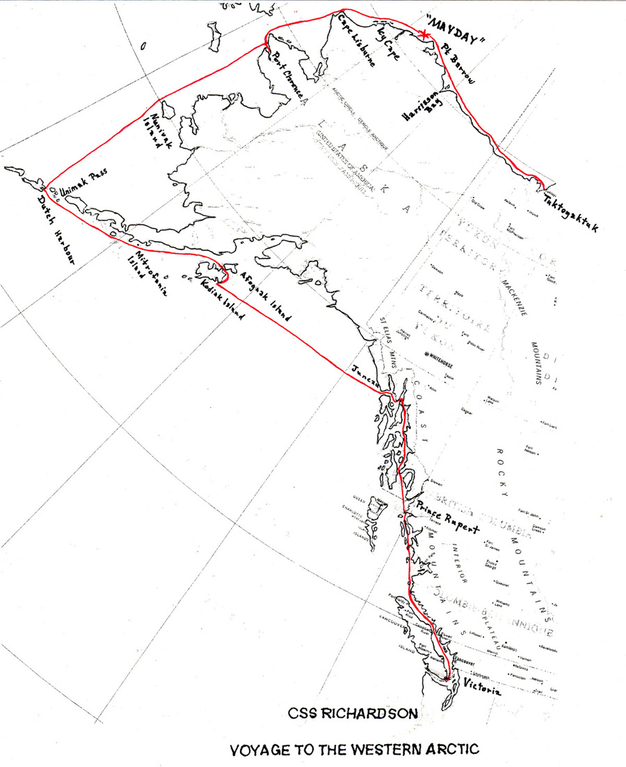
Click map above for larger image
"Richardson" sailed from Victoria on Dominion Day (1 July) and ran up the inside passage arriving at Prince Rupert on the afternoon of the 3rd July. After completing fueling, watering and adjusting compasses, she departed Prince Rupert on the afternoon of the 4th July, passing through Tongass Narrows opposite Ketchikan in time to witness a spectacular 4th July fireworks display. The rest of the voyage to Juneau was uneventful, "Richardson" arriving there shortly before dusk on the 5th July.
During July 6 "Richardson" fueled and watered, also obtaining U.S.C.G. ice information for the Point Barrow region and clearance to use fuel caches along the Alaskan coasts in areas where no regular fueling ports were available. She departed Juneau around supper time that day, entering the Gulf of Alaska early on the morning of July 7. As usual the waters were quite turbulent around Cape Spencer, but moderated somewhat further out into the gulf.
The gulf crossing was fairly routine, "Richardson" arriving at Kodiak early on the morning of July 9. Fuel, water and supplies were taken on board. The USN base was visited to obtain ice, weather and radio communications information. "Richardson" departed Kodiak early morning of July 10. The passage between Kodiak and Afognak islands was accomplished without incident. Proceeding down Shelikoff Strait the weather gradually deteriorated until by evening a moderate gale from the southwest was making the going extremely wet and miserable. However, by the time Mitrofania Island was abeam the following morning, the weather had improved considerably and passage through the Shumigan Islands was made in clear visibility and pleasant balmy breezes.
"Richardson" crossed Unimak Pass in reasonably good weather shortly after midnight on 11th July, arriving in Dutch Harbour the afternoon of 12th July in thick fog.
Fueling operations including extra fuel in drums on deck, and taking on of fresh water occupied the remainder of July 12. U.S.C.G.C. "Storis" tied up to the wharf this evening resulting in interesting renewals of acquaintanceships and the trading of information.
"Richardson" sailed from Dutch Harbour on the morning of July 13. Weather on the first day in the Bering Sea was good, slight sea and moderate swell with fog patches. Unfortunately this day the Fresh Water Evaporator went out of action. The next day the weather deteriorated somewhat making life a little more uncomfortable on board. By midnight on the 14th July Cape Mohican on Nunivak Island was abeam. Early on the 15th July a full south-southeasterly gale developed, but late evening on the same day the worst of the blow was over and shortly before breakfast on the 16th July "Richardson" was safely at anchor in Port Clarence.
During the 16th July the cache of fuel drums ashore was located and towed out to ship and loaded on board. On completion of fueling, Richardson moved to Fox Creek where fresh water was taken on board using floating hose and pump ashore. That afternoon "Richardson" anchored off Teller to give the ship's engineer an opportunity to locate parts for the evaporator. This attempt proved to be unsuccessful. The onshore wind increased off Teller forcing "Richardson" to shift her anchorage back to off the Loran Station at the entrance to the Harbour. The rest of the day was spent in attempting to repair "Richardson"s radar which had developed an intermittent fault on the voyage up the Bering Sea.
The following morning "Richardson" departed Port Clarence still suffering from inadequate radar signal strength, U.S.C.G.C. "Northwind" was passed in the vicinity of Cape Prince of Wales and on that afternoon, the 17th July, the vessel passed through the Bering Strait and headed up the Chuckohi Sea. That same afternoon the radar fault was fixed, much to our relief. The prospect of a voyage through the Arctic pack without radar, and with few landmarks available, would have been rather daunting.
By breakfast on the 18th July Cape Lisburne was abeam in moderate sea, vessel pitching moderately and spraying overall. At 1700 that day, just north of the Point Lay beacon the first scattered ice was observed with thick fog prevailing. By midnight, past Icy Cape, "Richardson" was maneuvering in 7/10 ths large floes.
Early on July 19 "Richardson" ran into slow going in 9/10 ths ice in the vicinity of Wainwright. The wind had switched to the SW and increased in velocity to more than 20 knots. By that evening progress had slowed to a few feet at a time, so we lay to in the ice and took advantage of the NE'ly drift. The wind continued SW'ly and moderately strong on the 20th July while the ship was in the vicinity of Franklin Point in 10/10 ths ice. Continual struggling to maintain progress resulted in broken steering hydraulic lines which were repaired, and a strong vibration in the hull indicating propeller and or shaft damage.
By the 21st July “Richardson” was beset by ice in the vicinity of Skull Cliff. The ice gradually came under increasing pressure and by the 22nd July the rafting ice was heeling "Richardson" over violently, first one side then the other. The situation was fast becoming extremely dangerous, therefore a "Mayday" signal was sent out at 1400 asking for immediate assistance. "Camsell" and POW 2 answered our call and within a short time "Camsell" was proceeding to our aid. The wind continued to blow moderately strongly from the SW.
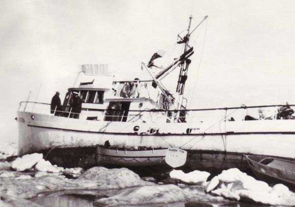
Caught in the Arctic Pack Southwest of Point Barrow
Two aircraft flew over our position that afternoon, keeping a watching eye on our predicament. Meanwhile we had the lifeboat and skiff swung out and provisioned. A likely looking floe was picked out as an emergency assembly point.
During the violent heeling motions caused by the rafting ice, the lifeboat was caught momentarily between an ice ridge and the ship's side. The squeeze caused the thwart and thwart knees to break away from the lifeboat hull, but the hull remained watertight and in appearance at any rate as seaworthy as ever.
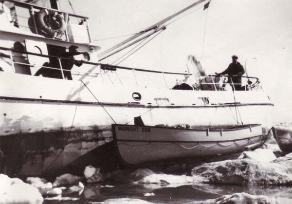
Caught in the Arctic Pack Southwest of Point Barrow
Point Barrow Radio asked if we wished to evacuate the vessel. Evacuation was declined as long as there was any chance of saving the ship. Point Barrow Radio then advised that it would take about 8 hours for a helicopter to get to our vicinity from Fairbanks. "Camsell" was about 30 hours steaming away to the eastward and "Northwind" a similar steaming time away to the SWward.
The excessive list made living conditions aboard very uncomfortable. The galley stove went out on several occasions and food was of the soup and sandwich variety at opportune moments. Around midnight on the 22nd the vessel listed violently over 35° to port and we prepared to abandon. By this time the floe we had picked as an assembly point was almost completely impacted and the situation did not look promising. Even had a helicopter been available I doubt if it could have landed safely on these shifting rafting floes.
By 0400 on the 23rd the heeling had eased to about 20°, but the ship rafted completely on top of the ice causing engine intake blockage resulting in our adoption of battery power.
Late on the evening of the 23rd when we had drifted to the vicinity of the Will Rogers Monument, helicopters from "Northwind" arrived overhead. At that point "Northwind" was 16 miles WSW of "Richardson" and "Camsell" was 20 miles east of Point Barrow. This coincided with a shift in the wind to the NE.
Early on the 24th July the ice pressure eased and "Richardson" was set free. A short time later "Camsell"s helicopter flew overhead. At that point we were off Barrow village.
In reviewing events of the previous six days it is obvious that the steady SW'ly wind, at times exceeding 20 knots, coupled with the normal NE set of the current along the coast toward Point Barrow, contributed greatly toward our eventual hazardous position.
To illustrate further, the main pack edge lay 20 miles off Icy Cape, 10 miles off Franklin Point and about 5 miles off Point Barrow. The loose ice lying between the main pack and shore was gradually pushed into a narrower and narrower funnel with all the resulting constriction and pressure build-up.
By 0730 a strong ice movement to the northward had "Richardson" held fast once again. At 1045 "Camsell"s helicopter landed alongside and Captain Strand reviewed the present ice situation. Apparently a large pressure ridge now effectively blocked their progress toward "Richardson".
At noon on the 24th July "Richardson" was five miles due north of Point Barrow and under increasing pressure from heavy ice. That afternoon "Northwind" passed close alongside, easing the pressure and also becoming the first vessel to make contact. Because of the pressure neither "Camsell" nor "Northwind" were able to break "Richardson" clear and the attempt was abandoned until the pressure eased. At midnight on 24th July we had drifted to a position 14 miles NE of Point Barrow.
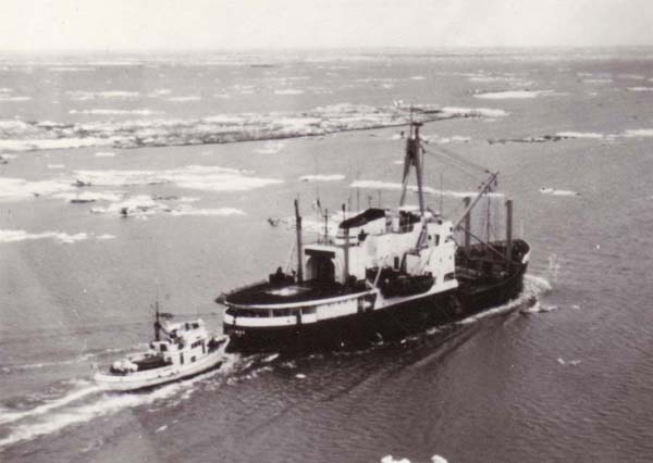
Early on the 25th July the ice pressure eased somewhat and "Camsell" was able to get a line on "Richardson". "Northwind" then broke ice for both vessels with progress very slow in rafted winter ice. It was finally agreed that "Northwind" would tow "Camsell" who in turn would tow "Richardson". Thus those two vessels in tandem, with a total horsepower in excess of 14,000, proceeded to pull "Richardson" through and often right over the top of 10/10ths heavily rafted ice. It was an experience never to be forgotten.
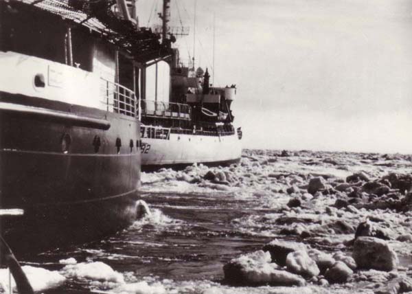
14,000 Horse power ride for "Richardson" astern of "Camsell" and "Northwind"
Late afternoon that same day we were in open water off Elson Lagoon. The 14,000 horsepower joyride broke the rudder-tiller key way cap, leaving "Richardson" unable to maneuver. When we attempted to lie alongside "Camsell" the hull vibration was intense and at full speed we barely moved through the water. An underwater inspection by "Camsell"s divers showed that our propeller was completely 'tuliped', but no other underwater damage could be ascertained.
On the 26th July "Richardson" again went under tow to "Cam sell" on the long haul along the Arctic coast to Tuktoyaktuk. "Northwind" was released to resume her oceanographic activities elsewhere. Luckily we were able to skirt the heavy ice by running along close inshore. Late that evening we were in the vicinity of Harrison Bay.
The following day, 27th July, "Camsell "-"Richardson" continued to make good progress to the eastward. By midnight our position was in the vicinity of Flaxman Island.
On the 28th July progress continued to be good until east of Barter Island when heavy ice concentrations were close inshore. The resulting maneuvers caused damage to the starboard gunwale and to the bow.
The following day, 29th July, in the vicinity of Clarence Lagoon, we once more ran into heavy ice concentrations. Progress became so slow that "Richardson" pulled alongside "Camsell" to change propellers. This operation was completed most efficiently and was very successful. Meanwhile "Camsell" had braize-bolted the key way cap and this too was fitted and tested successfully. We then loaded 1000 gallons Diesel Fuel from "Camsell" and topped up our fresh water tanks.
However, when we attempted to proceed independently, the diesel fuel supplied was discovered to have a high water content and some time elapsed before "Richardson" was able to get underway.
We then proceeded along a narrow lead as close to shore as we dared, then followed "Camsell" further offshore in 9/10 ths ice. At 2200 the pressure of moving ice on the rudder proved too much for the hydraulic system, and our steering gear was out of action once more.
Early on the 30th July repairs were effected and "Richardson" continued to follow "Camsell" in very heavy ice. At 1130 the key way cap cracked open once more and "Camsell" resumed towing. The steering gear was repaired around 1600 but by 1800 had broken down again. By this time "Richardson" was suffering extensive damage to the forward bulwarks and rails. At 2000 "Camsell" stopped as progress was negligible and thick fog hampered any real assessment of the correct direction to proceed. During the next few hours the polynya in which both vessels were lying shrunk considerably. As a result "Richardson" was squeezed between "Camsell"s counter and a large floe. The starboard bulwark and rail were buckled for a distance of twenty feet.
This evening was really the low point of our fortunes. We had been in far greater danger off Point Barrow, but morale remained high. Here, so close to Tuk, we seemed to be battering ourselves to bits to no avail.
However "Camsell" had repaired our key way cap once more, this time molding a piece of flat iron to fit over the cap. This arrangement was bolted over the key way cap and we were back in business.
The long tow along the North Coast of Alaska behind "Camsell"
The fog cleared on the morning of July 31st and by 1140 we had broken into an open water lead close inshore near Komakuk Beach. From this point "Richardson" was able to proceed independently toward Tuktoyaktuk. By late afternoon we were in open pack in MacKenzie Bay. Here we discovered that we were making water into the forepeak. Pumping continuously maintained the forepeak dry.
At 0930 on the 1st August "Richardson" entered Tuk Harbour. That afternoon she entered the drydock.