

Baffin
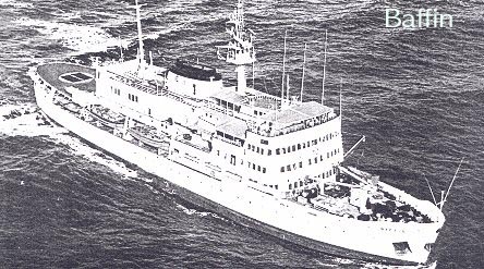
The CSS Baffin was built by Canadian Vickers in 1956 as one of the most modern hydrographic survey vessels in the world. She was accepted by the Department of Mines and Technical Surveys on January 22nd, 1957. She was 90 meters (LOA) with a displacement of 4986 tonnes and carried a Lloyd's Ice Class I registration. With a complement of 57 crew and accommodations for 29 scientific staff, she had an endurance of 76 days at a cruising speed of 10 kt. Originally fitted with 6 launches, 2 helicopters, 2 landing barges, she served primarily along Canada's eastern seaboard and in the Canadian Arctic as well as numerous missions to other parts of the world. She was decommissioned in1990.
(1958 notes): Launched 1957 - Gross tonnage: 3,460 - Length 272 ft - Total personnel 96 - Hydrographers 13
1965 off Sable Island experienced engine room failure. Returned to Halifax shipyards for repairs which lasted remainder of survey season.
|
Year |
HIC |
Capt./Sai. Master |
Location |
Survey Type |
1957 |
J.E.V. Goodwill |
D.M. Snelgrove |
Nova Scotia |
Hydrographic |
1958 |
D’.A.H. Charles |
W. Kettle |
NS, & Baffin Isl |
Various |
1959 |
NS, off southeast coast | Two-range Decca | ||
1959 |
W. Kettle | Hudson Strait | Hydrographic | |
1959 |
Exeter Bay (Cape Dyer, Baffin Island) | Inshore, Reconnaissance | ||
1962 |
East of Halifax, NS | Offshore | ||
1962 |
Barrow Str, westward Arctc | Offshore | ||
1962 |
Duke of York Bay, Southhampton Isl, Arctic | Reconnaissance | ||
1962 |
Alexis River, Labrador | Standard | ||
1963 |
R. Wills | Sable Island NS | Control and Sounding | |
1963 |
R. Wills |
Tail of the Bank |
Off-Shore |
|
1964 |
M. Bolton |
W.N. Kettle |
Caribbean |
Foreign |
1964 |
H.R. Blandford |
P.M. Brick |
Bay of Fundy |
Multidiscipline |
1965 |
F.L. DeGrasse |
N.S. returned to Halifax for repair |
Off-Shore (planned) |
|
1966 |
S. van Dyck |
W.N. Kettle |
Antigua, West Indies |
Training, Off-Shore |
1966 |
T.B. Smith |
Tail of the Bank |
Off-Shore |
|
1967 |
S. van Dyck |
P.M. Brick |
Antigua,West Indies Jamaica, West Indies |
Training, Harbour |
1967 |
F.L. DeGrasse |
Grand Bank of NL |
Off-Shore |
|
1968 |
S. van Dyck |
P.M. Brick |
St. Kitts, Barbados, West Indies |
Training, Harbour |
1969 |
S. van Dyck |
P.M. Brick |
Grenadines, Redonda, West Indies |
Training, Off-shore |
1969 |
F.L. DeGrasse | Gulf of St. Lawrence, eastern portion | Off-shore, Hydrographic and Oceanographic | |
1969 |
F.L. DeGrasse | Evaluation of Decca Lambda Positioning System | Gulf of St. Lawrence (6 Oct - 29 Oct) | |
1969 |
F.L. DeGrasse | Baie Des Chaleurs, N.B. | Wharf plan | |
1970 |
S. van Dyck |
P.M. Brick |
Canouan, West Indies |
Training |
1970 |
T.B. Smith |
Beaufort Sea, north of Tuktoyaktuk and Northwest Passage |
Deep Draft Vessel route, shoal areas, gravity and magnetic readings |
|
1970 |
T.B. Smith | Prince of Wales Strait, area around Princess Royal Islands priority. 30 Aug - Sept 19 | Standard, Shoal exams, Geophysical | |
1973 |
St. Lawrence River Estuary |
Multidiscipline |
||
1973 |
Sept Iles, Que | Harbour | ||
1973 |
Cape White Handkerchief, Labrador | Reconnaissance and Control | ||
1973 |
Lancaster Sound and Maxwell Bay, Arctic | Hydrographic |